Kanon der Sonnenfinsternisse von 2500 v. Chr. bis 1000 n. Chr. / Canon of solar eclipses 2500 BC to 1000 AD
Die Einträge in der Tabelle haben folgende Bedeutung: / The entries in the table have the following meaning:
| Date: | Datum der Sonnenfinsternis / date of the solar eclipse |
| Type: | Typ der Sonnenfinsternis / type of the solar eclipse |
| T ... total / total | |
| R ... ringförmig / annular | |
| RT ... ringförmig-total / hybrid | |
| P ... partiell / partial | |
| deltaT: | mittlerer ΔT-Wert in Sekunden / mean ΔT-value in seconds |
| tbeg: | Beginnzeit der Sonnenfinsternis in Terrestrischer Dynamischer Zeit (TDT): ein negativer Wert zeigt an, dass die Finsternis am Vortag begann |
| starting time of solar eclipse in Terrestrial Dynamical Time (TDT): a negative value indicates that the eclipse started on the day before | |
| tmax: | Zeitpunkt der grössten Finsternis in TDT: Minimum des Abstandes zwischen der Achse des Mondschattenkegels und dem Erdzentrum |
| instant of greatest eclipse in TDT: instant when the axis of the Moon's shadow cone passes closest to Earth's centre | |
| tend: | Ende der Sonnenfinsternis in TDT / end of solar eclipse in TDT |
| place: | Ort für den die folgenden Einträge gelten / site for which the following entries apply |
| mag: | maximale Magnitude der Sonnenfinsternis am Ort / maximum magnitude of the solar eclipse at site |
| tm: | Zeitpunkt in wahrer Lokalzeit der grössten Magnitude am Ort / instant of maximum eclipse at site in true local time |
| PE: | Positionswinkel der Sonne bei Finsternisbeginn: wird vom Sonnenmittelpunkt aus von Nord (0°) über Ost (90°), Süd (180°) und West (270°) gezählt |
| position angle of Sun: measured from the centre of the Sun from north (0°) to east (90°), south (180°) and west (270°) | |
| PA: | Positionswinkel der Sonne bei Finsternisende / position angle of the Sun at the end of the eclipse |
| ZE: | Vertikal-Positionswinkel bei Finsternisbeginn: wird vom lokalen Zenit aus (0°) gegen Osten (90°), Süden (180°) und Westen (270°) gezählt |
| position angle vertex: measured from the centre of the Sun from the local zenith (0°) to east (90°), south (180°) and west (270°) | |
| ZA: | Vertikal-Positionswinkel der Sonne bei Finsternisende / position angle vertex of the Sun at the end of the eclipse |
| Identification: | Quellentext falls schriftlich belegt / source if literally known |
| Map: | Karte(n) mit Sichtbarkeitsgebiet der Sonnenfinsternis / map(s) with eclipse paths |
| eclipses with mag <0.5 | ||||||||||||||
| Date | Type | deltaT | tbeg | tmax | tend | place | mag | tm | PE | PA | ZE | ZA | Identification | Map |
|---|---|---|---|---|---|---|---|---|---|---|---|---|---|---|
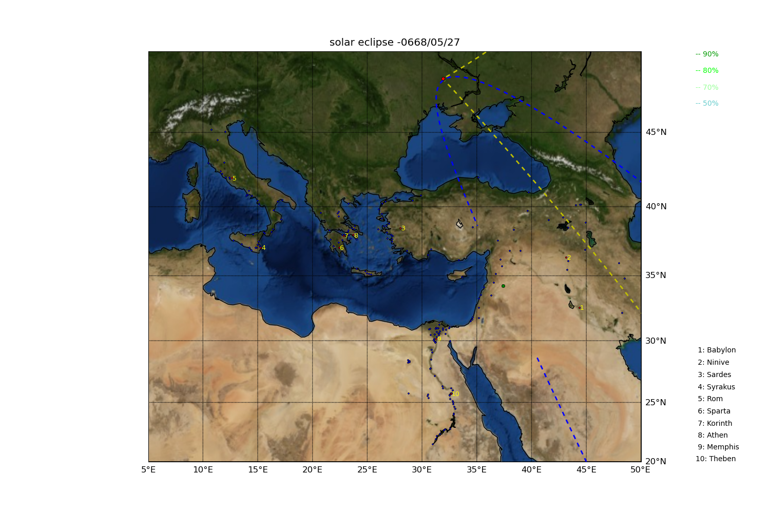
| 669/05/27 BC | R | 19573.5 | 5.2754 | 8.3472 | 11.3262 | Babylon: | <0.500 | 0.0000 | 0.0 | 0.0 | 0.0 | 0.0 | Issar-Shumu-Eresh, RMA 274B | solec-06680527 |
| Athen: | <0.500 | 0.0000 | 0.0 | 0.0 | 0.0 | 0.0 | Rasil, RMA 269 | |||||||
| Memphis: | <0.500 | 0.0000 | 0.0 | 0.0 | 0.0 | 0.0 | ||||||||
| Theben: | <0.500 | 0.0000 | 0.0 | 0.0 | 0.0 | 0.0 | ||||||||
| Rom: | <0.500 | 0.0000 | 0.0 | 0.0 | 0.0 | 0.0 | ||||||||
| Alexandria: | <0.500 | 0.0000 | 0.0 | 0.0 | 0.0 | 0.0 | ||||||||
| Knossos: | <0.500 | 0.0000 | 0.0 | 0.0 | 0.0 | 0.0 | ||||||||
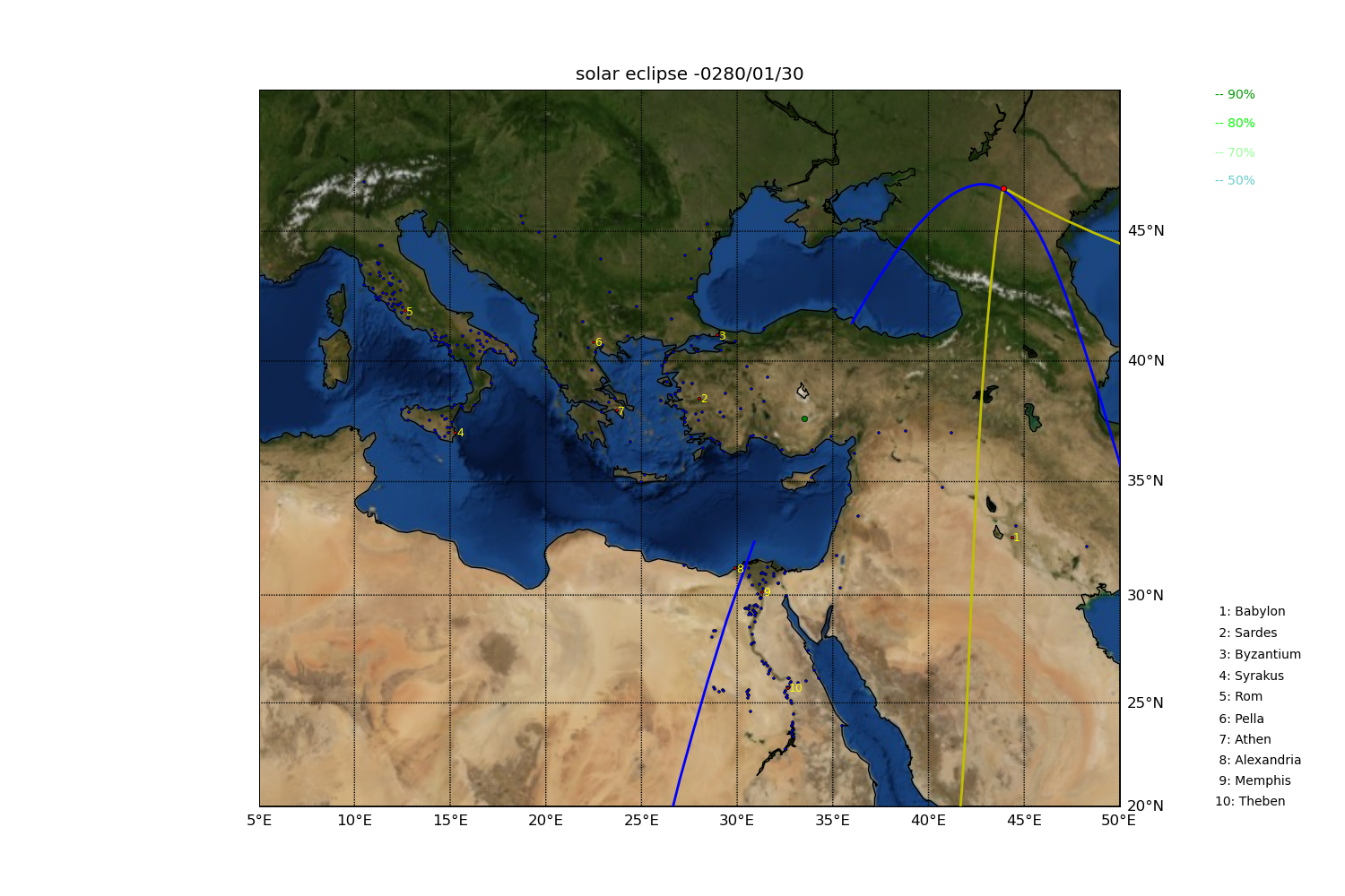
| 281/ 1/30 BC | R | 13729.2 | 6.3575 | 9.3042 | 12.1222 | Babylon: | <0.500 | 0.0000 | 0.0 | 0.0 | 0.0 | 0.0 | BM 41660 | solec-02800130 |
| Athen: | <0.500 | 0.0000 | 0.0 | 0.0 | 0.0 | 0.0 | ||||||||
| Memphis: | <0.500 | 0.0000 | 0.0 | 0.0 | 0.0 | 0.0 | ||||||||
| Theben: | <0.500 | 0.0000 | 0.0 | 0.0 | 0.0 | 0.0 | ||||||||
| Rom: | <0.500 | 0.0000 | 0.0 | 0.0 | 0.0 | 0.0 | ||||||||
| Alexandria: | <0.500 | 0.0000 | 0.0 | 0.0 | 0.0 | 0.0 | ||||||||
| Knossos: | <0.500 | 0.0000 | 0.0 | 0.0 | 0.0 | 0.0 | ||||||||

Diese Arbeit wurde vom Schweizerischen Nationalfonds im Rahmen eines Marie Heim-Vögtlin
Stipendiums finanziert.
This work was supported by a Marie Heim-Vögtlin grant of the Swiss National Science Foundation.